
Unfortunately no pictures today, the Internet is slow but we’re not complaining!
Started the day in Salida and the route puts us on a nice bike path to Poncha Springs, about five miles west. The path itself has about a 1.5% uphill grade so it just had the slightest bit of extra resistance. Then we headed south alongside US 285. Before we got too far we made a stop for breakfast at Mabel’s Cafe. They sure do love breakfast burritos in Colorado and these were great, made to order. We also bought some caloric supplies for the day and used the bathrooms multiple times.
The shoulder along 285 was wide but it was still nerve wracking. We got a good chunk of our climbing in, about 1500 ft of our 3700 ft in only five miles. Steeper than the rest of the day but paved. At one point the shoulder was closed so we dashed across and rode against traffic because taking the lane was not an option.
We were glad to get to the dirt/gravel Marshall Pass Road! Almost immediately, a Brian rider was traveling northbound and gave us a bunch of intel about what we’d see and his experiences. He was from Santa Fe and his info about the Abiquiu to Santa Fe transit/route options was well received! His grading scale for gravel ranges from Champagne gravel (which was at the bottom of this route and was almost like packed dirt or clay) to box wine gravel (which is what most of the route would be today and was generally ok but still requires some diligence on path selection). As per usual, the conditions deteriorated the higher we got.
The climb was steady and there was almost no traffic. The route follows an old railroad grade so it was very consistent 2-3%. Easy riding for us but it took a lot of miles to cover the elevation! Beautiful vistas of the surrounding mountains and valleys and a windy ascent made for an interesting ride. At least, for the first two hours/ten miles when we began to feel like this climb had perhaps overstayed its welcome! It was also surprisingly warm with the Wahoo computer reporting 89F in the shade. We began to tackle it in 250ft chunks which was something like 20 minutes blocks. Then we’d find some shade and continue. Finally some clouds began to move in as we approached the pass.
The Colorado Trail also crossed at this same point and we briefly chatted with two hikers about their journey. They start in Denver and continue to Durango. They were a bit aloof though; perhaps there isn’t the level of camaraderie between hikers and bikers that one might think. Tribes!
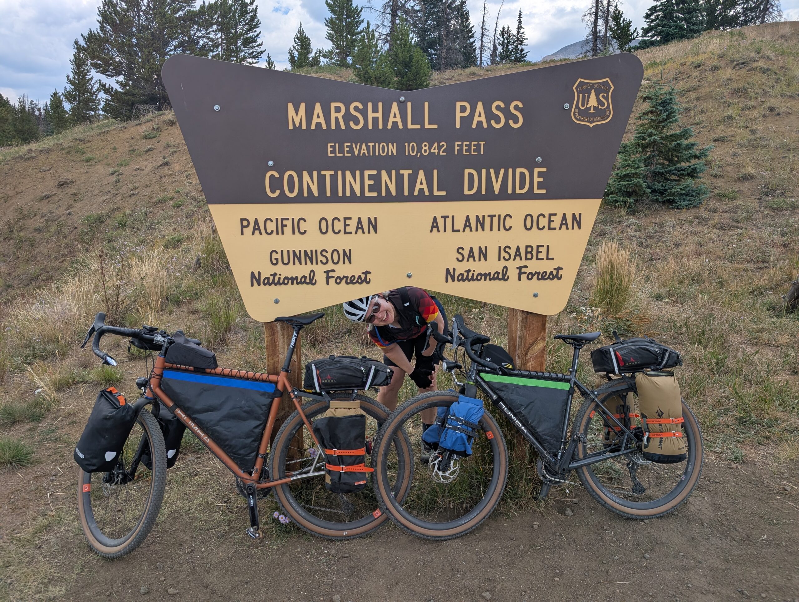
Liz and I snapped some pics at the top and then started our descent. (s/o to Harald who knew the minute we had crossed and sent us a message on our satellite messenger!) This was our second time crossing the Continental Divide on this trip and this was a much more pleasant experience, even if it too was an hour longer than it needed to be! Speeds of 10-14mph were common and we were able to use the entire road in finding smooth paths because you could easily hear cars coming by, of which there were almost none.
Near the bottom as we approached our destination, Sargents, we waved as a biker who’d passed us coming up the other side in our direction was doubling back to Salida. He was testing out his rig with a “quick out and back” in preparation for a race from Salida to the Pacific Ocean? Maybe? Some ocean for sure. Good luck guy!
Sargents is a town with one feature and that’s an all in one gas station, restaurant, convenience store, RV park, cabin rental and yes, tent camping. The town is on US 50, which we’re routed on tomorrow for 12 miles. We’ll see about that!
When we arrived we saw two other thru-biker rigs parked in front. Inside we found the riders and struck up a conversation with them, Allison and Alan or Al and Al. They had come from Salida as well, just an hour before us and have been biking the trail since Jasper, Alberta.
They probably tend to cover a bit more mileage than we do per day, but tomorrow’s route may end in the same spot for both of us because there aren’t too many good options. So Allison is going to try to get some of the local ranchers to take us down US 50 in their truck so we can avoid riding that stretch. That will also take about an hour off of tomorrow’s ride time.
So we’ll see how that all plays out! They seem excited to potentially have someone near them on the trail. Even if we don’t rise together at the same pace, there is comfort in sharing a plan and having meeting points further down the trail. So we’ll see!
Bedtime now. Listening to a babbling brook should help us get to sleep.
3 responses
I think there need to be additional gravel gradations! Malort gravel? Moonshine gravel? Cough syrup gravel?
Bummer about the connecting stretches on major highways. US-50 looks decidedly unfun on Streetview. Fresh pavement, but no real shoulder. Hope you can hitch a ride!
Thank you for these wonderful updates!
Thanks Jim!